My 30DayMapChallenge 2020
World Map Challenge
- Tools
- QGiS, GRASS GIS, SAGA GIS, GDAL, Python, Blender, Inkscape, GIMP and Ubuntu 18.04.
- Data
- OpenStreetMap contributors
- Project Type
- Challenge
This year, as well as 2019, I took part in the best cartographic challenge #30DayMapChallenge where participants from all over the world created beautiful maps on the theme of each day.
Unlike last year, other cartographers from Ukraine also took part in the marathon. The map from Andriy Yaremenko is very interesting and unusual and maps from some cartographers. As there will be statistics, I will attach them to the publication.
You can see many interesting and incredible works under the hashtag #30DayMapChallenge on Twitter.
The official repository for #30DayMapChallenge is a daily mapping/cartography/data visualization challenge aimed at the spatial community.
I am incredibly grateful to the wonderful Topi Tjukanov from Helsinki, Suomi for organizing this wonderful and much-needed cartographic holiday. Of course, it is difficult to come up with and make a map every day, but it is definitely worth it!
Here are my 30 maps about Ukraine. Enjoy!
Day 01: Points
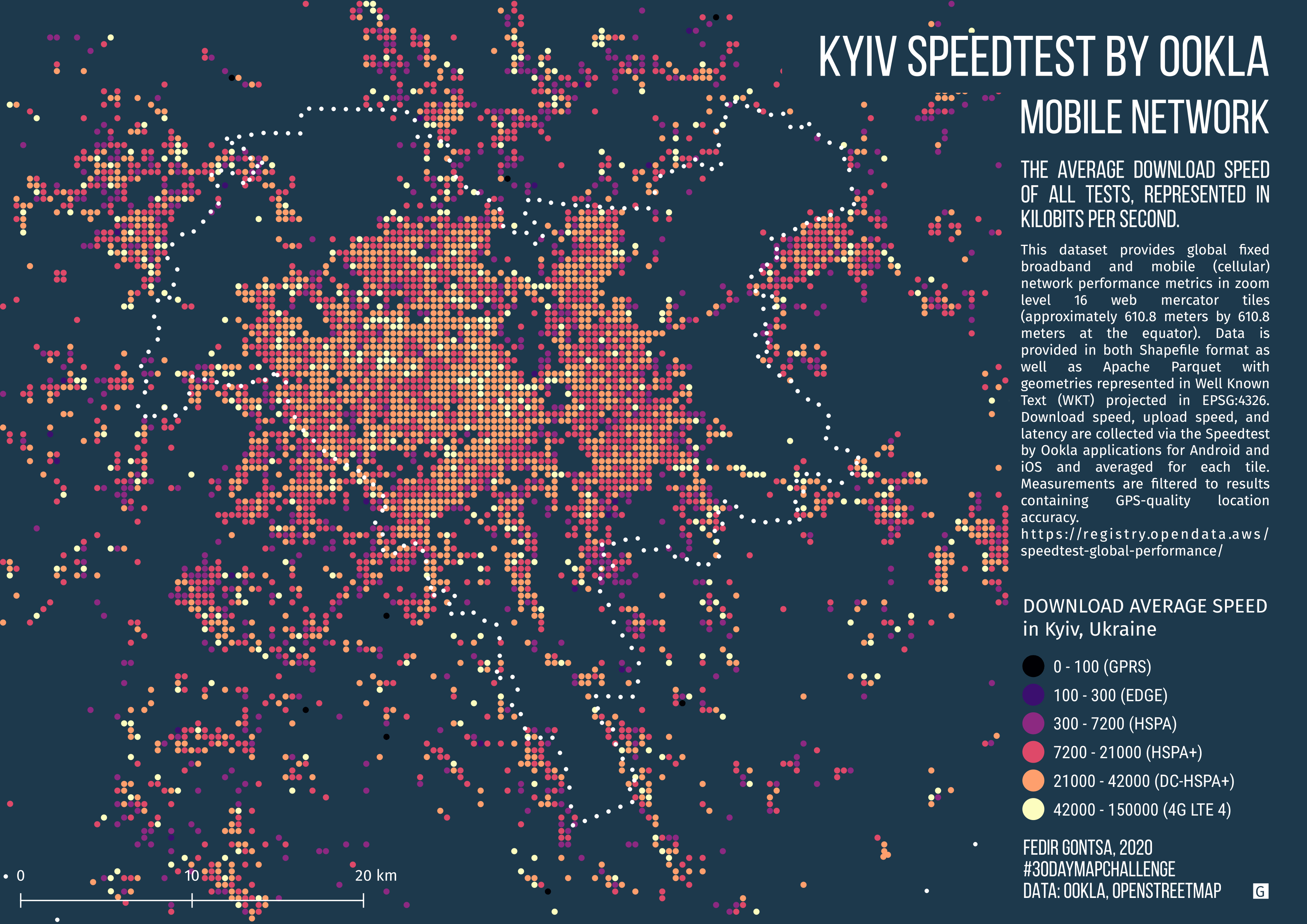
Speed test Mobile Network data in Kyiv, Ukraine. (2020, quarter 3 / 2020-07-01)
Data: Speedtest by Ookla Speedtest OpenStreetMap contributors, QGIS, SAGA

Day 02: Lines
Ukrainian cities with a population of more than 250,000 inhabitants as of 2014.
Square-mile street network visualization.
#30DayMapChallenge Day 02: Lines
tools: Python, OSMnx, Jupyter-lab, Inkscape data: OpenStreetMap
Thank you @gboeing for the excellent tools!

Day 03: Polygons
Danube Delta. The Romania–Ukraine border.
#30DayMapChallenge Day 03: Polygons
lines are also polygons (buffer + merge + dissolve)
Tools: #QGIS data: #OpenStreetMap contributors

Day 04: Hexagons
Ukrainian Greek Catholic Church in Galicia, Ukraine
#30DayMapChallenge Day 04: Hexagons
#QGIS #OpenStreetMap
In the spring of 2020, we marked more than 1,000 Ukrainian Greek Catholic churches with the @osm_ua community. This is an attempt to visualize this data.

Day 05: Blue
Lake Synevyr is the largest lake in the Carpathian Mountains of Ukraine.
Located at an elevation of 989 meters above sea level.
The name is formed from the words Blue and Whirlpool, the locals also call this lake Sea Eye.
#30DayMapChallenge Day 05: Blue
Tools: #QGIS data: #OpenStreetMap contributors

Day 06: Red
Today is the 60th anniversary of the opening of the first (Red) Line of the Kyiv Metro. This map is about the stages of development of the Red Metro Line
#30DayMapChallenge Day 06: Red
Tools: #QGIS data: #OpenStreetMap contributors
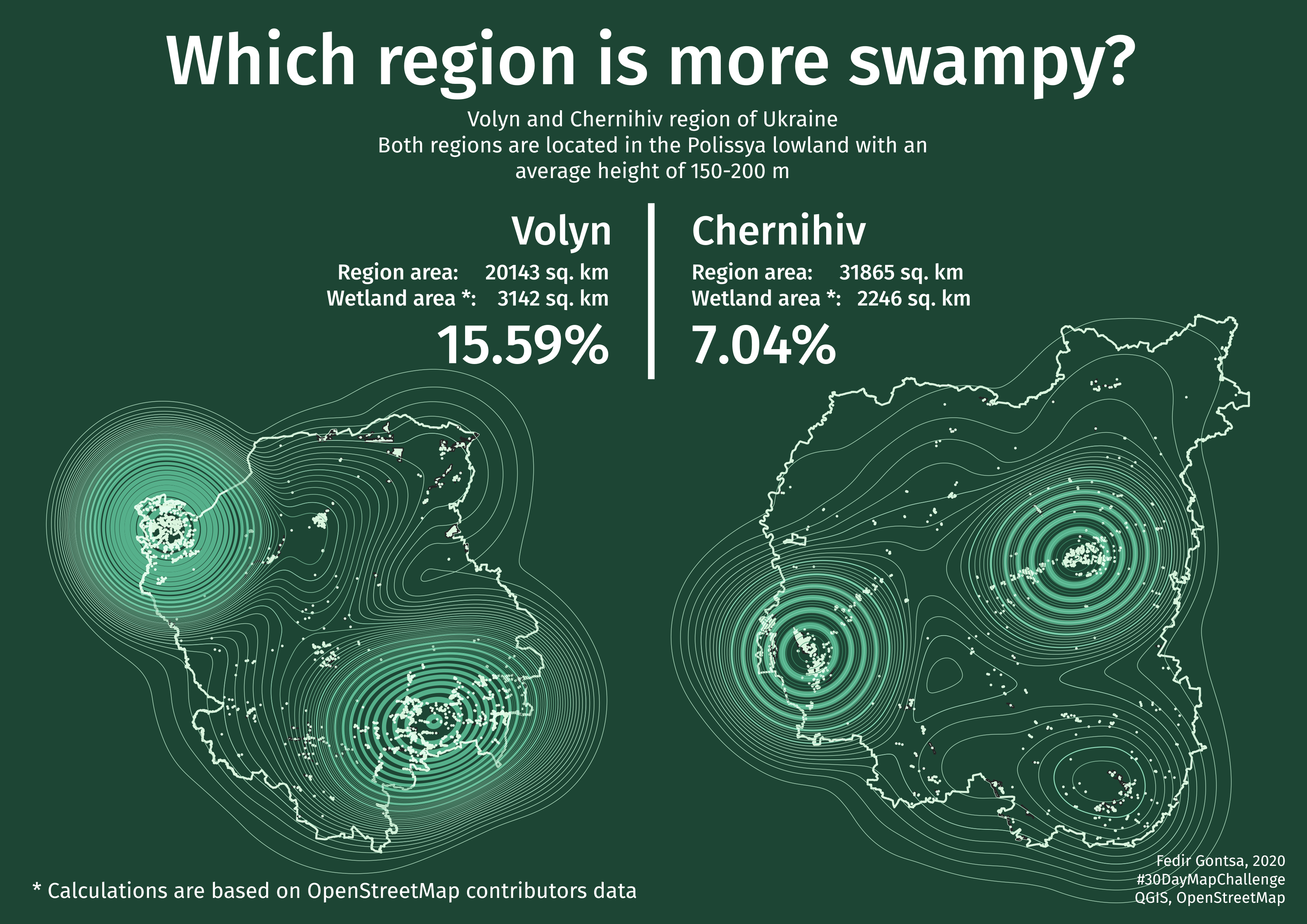
Day 07: Green
Which region is more swampy — Volyn or Chernihiv?
#30DayMapChallenge Day 07: Green
Tools: #QGIS data: #OpenStreetMap contributors

Day 08: Yellow
Oleshky Sands
#30DayMapChallenge Day 08: Yellow
#QGIS, GDAL, #OpenStreetMap, SRTM, #Landsat 8

Day 09: Monochrome
Part of Carpathian Biosphere Reserve + color variations
#30DayMapChallenge Day 09: Monochrome
#QGIS, GDAL, #OpenStreetMap, SRTM

Day 10: Grid
Tile Grid Map of Ukraine
This is an attempt to make this type of map for Ukraine
#30DayMapChallenge Day 10: Grid
#QGIS, Inkscape, #OpenStreetMap contributors
Other versions (1, 2, 3)

Day 11: 3D
Slovechansko-Ovruch ridge, Ukraine
#30DayMapChallenge Day 11: 3D
#QGIS, #Blender, #Inkscape, SRTM

Day 12: Map not made with GIS software
Sometimes we find ourselves in a place that is unfamiliar and incomprehensible to us. We try to find signs that are familiar to us, but they only confuse us. This map is about the relationship between physical and psychological space 🙂
Where am I?
I once got lost in a plain old park and it was something like that. All guidelines were wrong 😉 So this map is about confusion.
Footprints to nowhere
#30DayMapChallenge Day 12: Map not made with GIS software
MyPaint, Inkscape
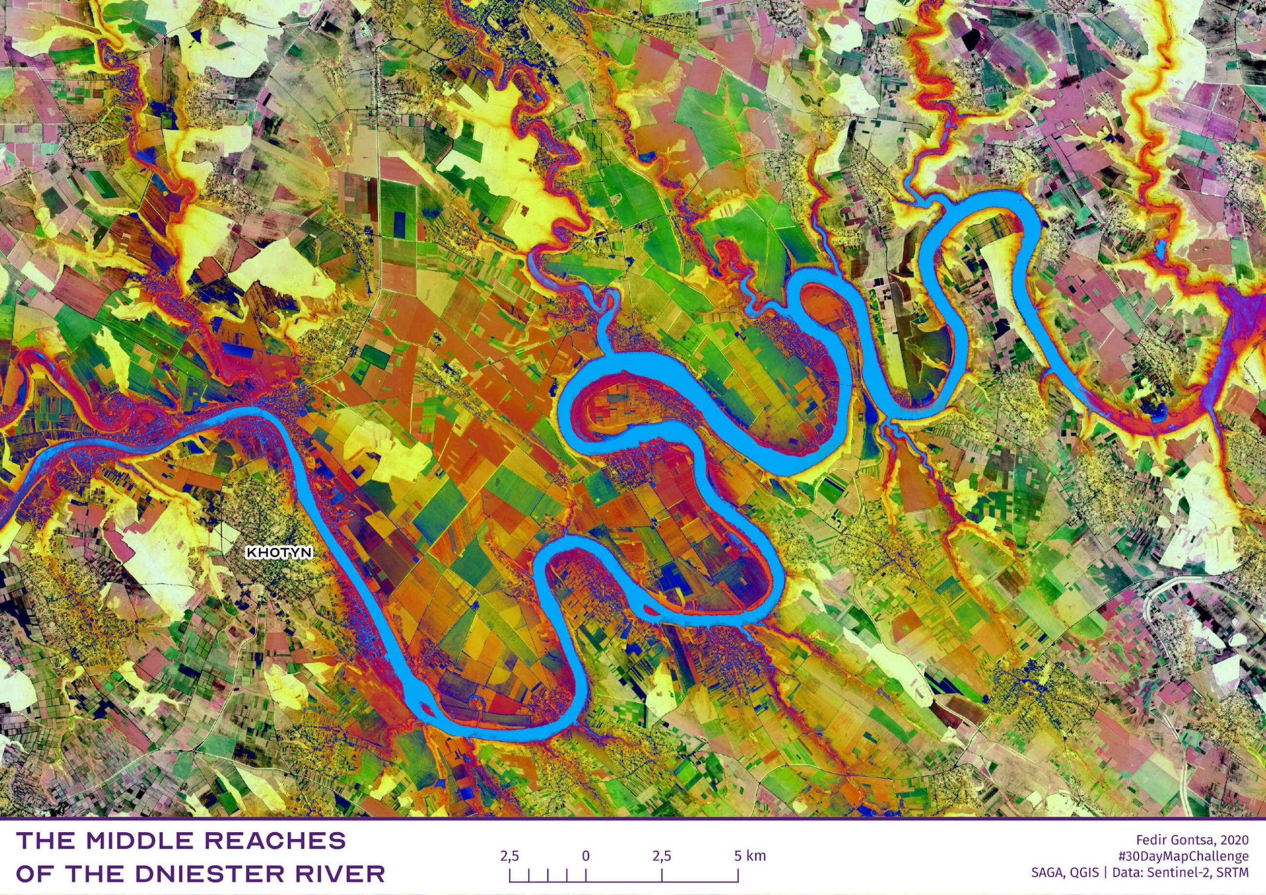
Day 13: Raster
The middle reaches of the Dniester River, Ukraine.
#30DayMapChallenge Day 13: Raster
Tools: SAGA GIS, QGIS. Data: Sentinel-2, SRTM

Day 14: Climate change
Ukraine. Emissions of Carbon Dioxide into the atmosphere by region
#30DayMapChallenge Day 14: Climate change
#QGIS Data: UkrStat.org

Day 15: Connections
New administrative divisions of Ukraine after 2020
#30DayMapChallenge Day 15: Connections
#QGIS Data: #OpenStreetMap contributors, personal

Day 16: Island(s)
Snake Island. Black Sea
#30DayMapChallenge Day 16: Island(s)
QGIS, GDAL Data: Sentinel-2, OpenStreetMap

Day 17: Historical map
Reconstruction of the Dnipro river (Ukraine) riverbed before flooding by the reservoir in 1959.
#30DayMapChallenge Day 17: Historical map
QGIS, OpenStreetMap, Old Maps, My Personal project files

Day 18: Landuse
Sumy, Ukraine. Simple land use plan
#30DayMapChallenge Day 18: Landuse
#QGIS Source: #OpenStreetMap contributors

Day 19: NULL
Based on:
https://www.vodafone.ua/services/network/coverage-map
https://kyivstar.ua/uk/mm/mobile-internet/karta-pokrytiya-3g
https://www.lifecell.ua/en/mobile-internet/
No 3G or 4G coverage map in Ukraine.
#30DayMapChallenge Day 19: NULL
#QGIS, #Python, Coverage maps of main mobile operators
Thanks for the map idea @mrpetruccio

Day 20: Population
Population by regions of Ukraine. The ratio of births and deaths, immigrants and emigrants by regions
#30DayMapChallenge Day 20: Population
#QGIS #OpenStreetMap contributors Source: ukrstat.org

Day 21: Water
Beautiful and dangerous lower reaches of the river Pripyat, Ukraine
#30DayMapChallenge Day 21: Water
QGIS, GDAL, OpenStreetMap, Sentinel-2

Day 22: Movement
Lviv (Ukraine) city center movement
#30DayMapChallenge Day 22: Movement
#QGIS GDAL, #OpenStreetMap, Strava tracks

Day 23: Boundaries
Hetmansky and Slobozhansky National Nature Parks. Sumy and Kharkiv Oblast of Ukraine.
#30DayMapChallenge Day 23: Boundaries
#QGIS, #OpenStreetMap, #Wikipedia

Day 24: Elevation
The Ukrainian Carpathians are a section of the Eastern Carpathians, within the borders of modern Ukraine. Ukrainian Carpathians belong to two distinctive categories, with major part belonging to the Outer Eastern Carpathians and minor part to the Inner Eastern Carpathians.
The Ukrainian Carpathians.
#30DayMapChallenge Day 24: Elevation
#QGIS, #OpenStreetMap, #Wikipedia, SRTM

Day 25: COVID-19 (Cartogram)
Percentage of patients (infected) to the total population in the regions of Ukraine
#30DayMapChallenge Day 25: COVID-19
#QGIS, Data by National Security and Defense Council of Ukraine

Day 26: Map with a new tool
Coefficients of monetary valuation of land in Dubno, Rivne Region, Ukraine.
#30DayMapChallenge Day 26: Map with a new tool
#kepler.gl, data.gov.ua
Online Map
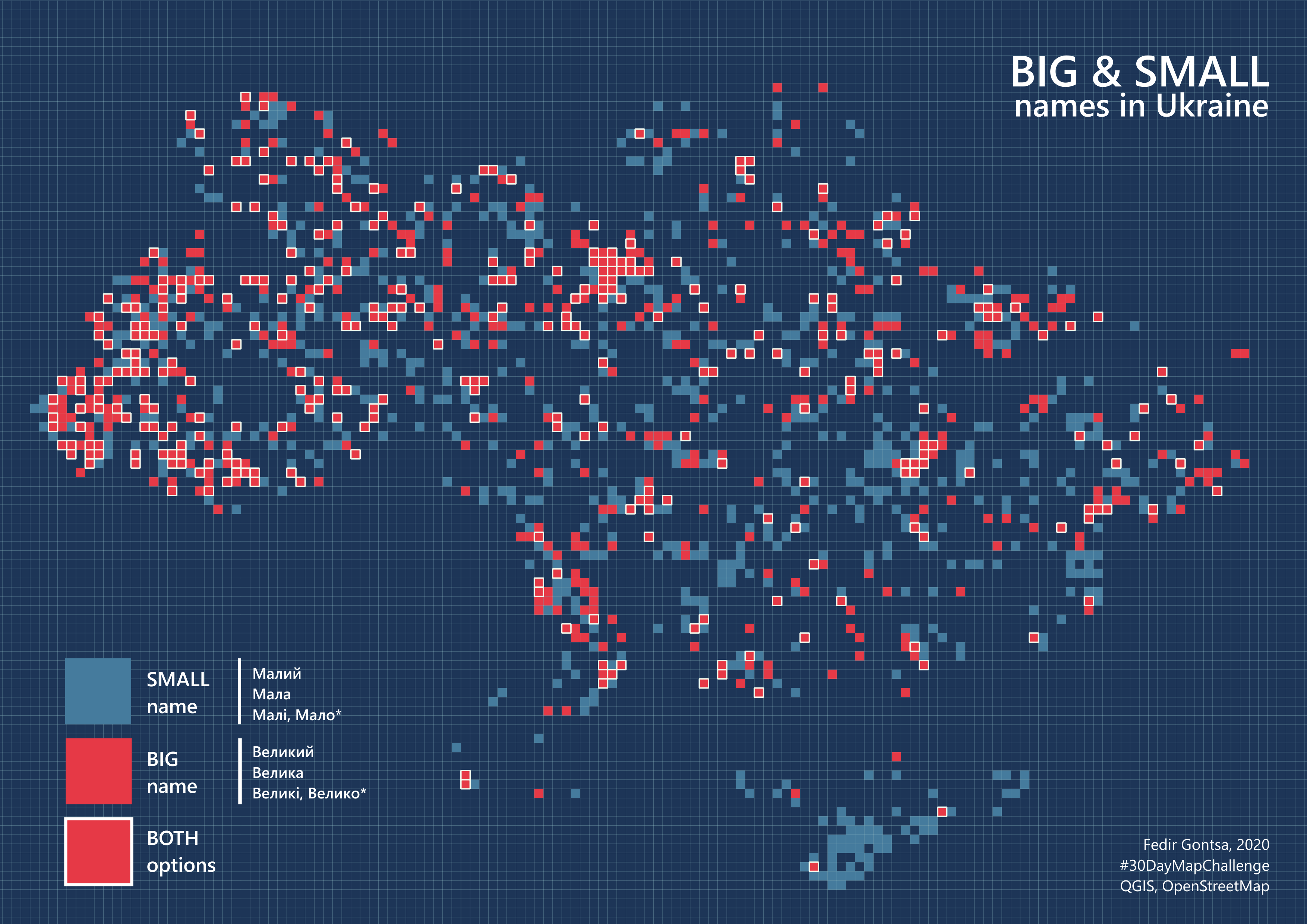
Day 27: Big or small data
Big and Small names in Ukraine. Big data for all names small cells for density
#30DayMapChallenge Day 27: Big or small data
#QGIS, #OpenStreetMap

Day 28: Non-geographic map
Basic visual connections and compositional axes in park “Sofiyivka”, Uman (Cherkasy region), Ukraine.
This is part of my research.
#30DayMapChallenge Day 28: Non-geographic map
#QGIS, #OpenStreetMap, Personal research

Day 29: Globe
Hello, I’m here.
#30DayMapChallenge Day 29: Globe
#QGIS, Natural Earth Data

Day 30: A map
Crimea | Qırım
The map labels the names of settlements in the Crimean Tatar language, the language of indigenous people of Crimea.
#30DayMapChallenge Day 30: A map
#QGIS, STRM, Natural Earth Data, #OpenStreetMap contributors
That’s all!
Thanks for watching all my work
over this incredible month!

